Tracsis Geo Intelligence provides a comprehensive linear infrastructure modelling solution, enabling Transport Companies to effectively plan and manage its transportation corridors.
We approach this challenge in four stages:
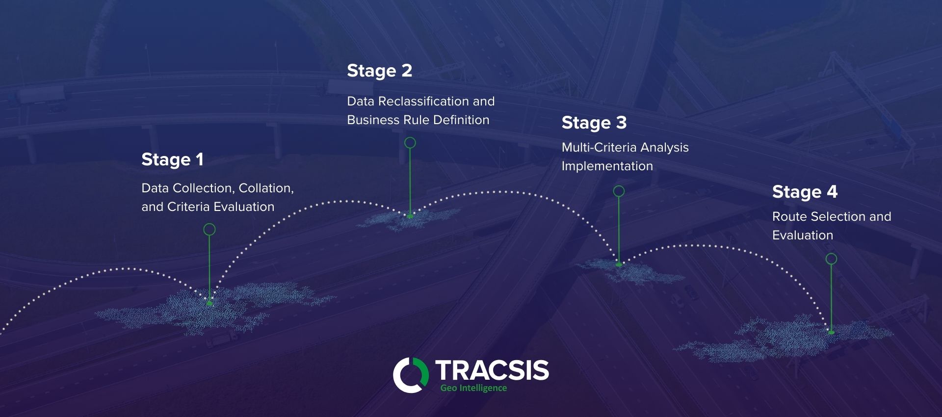
1. Data Collection, Collation, and Criteria Evaluation:
Our team of specialists gather and integrate diverse datasets, including:
-
- High-resolution elevation data (DEM) to assess terrain and slope.
- Geological maps and soil data to evaluate terrain stability and potential hazards.
- Existing infrastructure data (roads, railways, pipelines) to identify potential conflicts and synergies.
- Environmental datasets (protected areas, water bodies, sensitive habitats) to minimise environmental impact.
- Cost data (construction, land acquisition) to optimise route economics.
- Client provided origin and destination coordinates of proposed projects.
Our team then work closely with the Transport Company to define critical criteria and weightings for each dataset, reflecting the company’s priorities and operational requirements.
2. Data Reclassification and Business Rule Definition:
We define the “business rules” of the model, establishing the relative importance of each dataset in determining optimal routes. Data then gets reclassified and standardised to ensure consistency across the model. For example, slope values are categorised into risk levels, and proximity to protected areas was assigned a penalty score.
3. Multi-Criteria Analysis Implementation:
All relevant datasets are converted to a common raster format. Weighted overlay analysis are carried out, combining the reclassified datasets based on the defined business rules. This analysis generates a cost surface, representing the overall suitability of each location for infrastructure development, considering all relevant factors.
*The use of GIS decision support systems are paramount in this process.
4. Route Selection and Evaluation:
- Using the cost surface, we implement a least-cost path algorithm to generate optimal route proposals between specified origin and destination points.
- Multiple route alternatives are generated and evaluated, considering factors like length, cost, environmental impact, and risk.
- Detailed reports and maps are generated, providing Transport Companies with comprehensive information on each route proposal, including:
- Route alignment and length.
- Estimated construction costs.
- Potential environmental impacts.
- Risk assessments for identified hazards.
- ESRI file geo-database output.