Skip to content

Efficiently manage and analyse your river networks through a user-friendly web interface.

Tracsis Geo Intelligence offers a reliable, in-depth and user-friendly River Network Management System designed to streamline the management and maintenance of river network data. This system provides a comprehensive solution for various stakeholders, including:

  • LocalAuthorities
  • Environmental Scientists
  • National agencies managing wildlife, fisheries, and water quality.
  • WaterResourceManagers
  • Hydrologists

Service Offering

We provide a comprehensive managed service that includes:

The Tools we provide.

Tracsis Geo Intelligence has created Web tools to find all upstream and downstream rivers from a user selected point.

  • Proximitytools to find features from multiple different datasets located upstream and downstream from an input point.
  • Hydrological Modelling Tools to simulate river flow and flood inundation. Data Visualisation Tools Interactive maps and charts to visualise and explore data.
  • DataAnalysisTools that allow users to use statistical analysis and data mining techniques to uncover insights.
  • GIS capabilities for spatial analysis and mapping.
  • Custom Application Development to allow solutions to meet specific needs.

Capture Data Against Your River Network

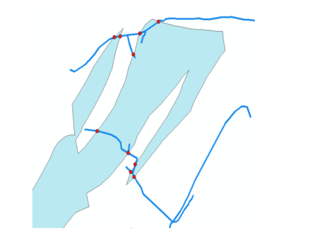
Web based tools could be used to mark-up sections of the river network.

For example:

  • Grant access to Inland Fisheries to markup salmonid waters
  • Capture weirs and barriers to allow more accurate upstream solving

These datasets can then be served-out from the platform using open web services. In addition to manual data entry the platform will allow full datasets to be referenced against the river network, for example snapping national point datasets, or intersecting polygon datasets with the river network.

Find out more

Complex editing of river networks through a web browser.

  • Create, modify, and remove river network edges.
  • Assign river network sinks.
  • Automatically calculate flow direction.
  • Move river edges between hydrometric area boundaries.

User Support

We provide an online service desk to users allowing them to log support tickets, and keep track of associated help and fixes to ensure any queries are answered or issue fixed.

Stay Ahead of Regulatory Deadlines

With strict EU and UK regulations on flood risk and water quality reporting, expanding pollutant monitoring requirements, and ongoing data gaps, timely, accurate, and spatially coordinated river monitoring has never been more critical.
How can we help?

Start the Conversation

Get the answers you need. Start your geospatial journey with Tracsis Geo Intelligence and get in touch with our specialists to learn more.

This field is for validation purposes and should be left unchanged.
Name(Required)
Email(Required)
Please let us know what's on your mind. Have a question for us? Ask away.