Skip to content

Monitor & Manage Land Use & Condition with Precision

Tracsis Geo Intelligence has developed an advanced Land Management System that integrates cutting-edge GIS technology, Earth Observation data, and machine learning analytics to deliver actionable insights for land and environmental monitoring.

Created in collaboration with our sister company Compass Informatics, the platform combines geospatial expertise with innovative data solutions to support effective land management.

Designed for NGOs, planning authorities, infrastructure owners, and private organisations, the system enables evidence-based decision-making, regulatory compliance, and sustainable land stewardship.

Data Innovation of the Year Award Winner 2024 – DAFM 

Defra Group Bodies & UK Paying Agencies

Advanced GIS-Based Land Management System

Built for flexibility, scalability, and precision, our platform integrates open-source and commercial satellite imagery, aerial data, and advanced spatial analytics. Organisations gain a comprehensive view of land-use dynamics, environmental conditions, and infrastructure development across any region.

We will leverage the latest technologies—including cloud-native architectures, scalable storage, advanced machine learning models, and modern geospatial frameworks to ensure our land management systems are robust, high-performing, and future-ready platforms for  land condition monitoring. 


Monitoring Land at Scale

Using Sentinel-2 satellite data, our Land Management System enables national-scale land monitoring. Its parcel-based model, rather than pixel-based, allows it to scale efficiently across large agricultural monitoring systems.

In the UK, this approach supports robust land-use monitoring aligned with Environmental Land Management schemes, including the Sustainable Farming Incentive, Countryside Stewardship, and Landscape Recovery. Bespoke time-series algorithms continuously assess land parcels, detecting changes and reporting them at Field of Interest level directly into national agricultural payment and regulatory systems.

In Ireland, our solutions help the Department of Agriculture, Food and the Marine reliably manage €1.5B in annual subsidy payments, providing a centralised, accurate, and cost-effective system for transparent land monitoring. This improves decision-making, resource management, and agricultural sector visibility.

See full case study

Post-Brexit Agricultural Subsidy Management and Environmental Compliance

Following Brexit, the UK government is implementing new agricultural subsidy schemes, moving away from the EU’s Common Agricultural Policy (CAP) and towards a system focused on environmental land management. This transition presents several challenges:

  • Environmental Land Management Scheme (ELMS) Monitoring
  • Enforcement of Environmental Regulations
  • Detecting Unauthorised Land Use Changes
  • Efficiently Managing Public Lands
  • Resource Strain

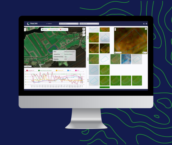
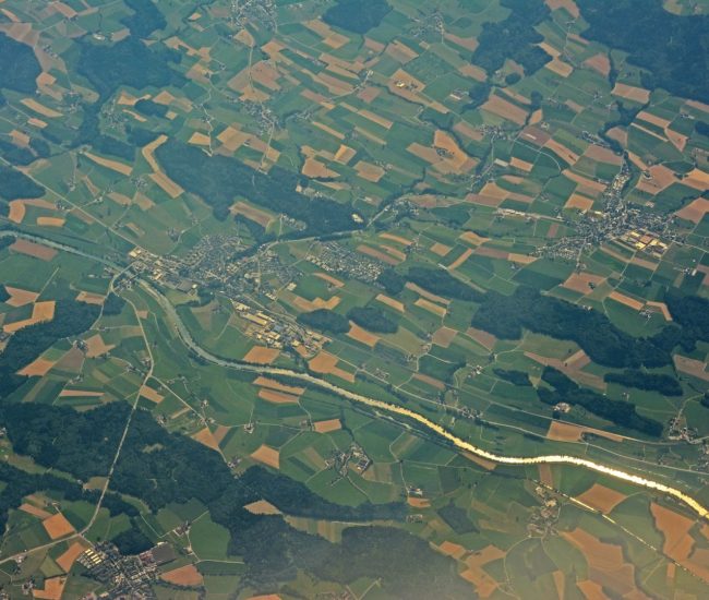
Our Land Management System uses satellite imagery and AI to monitor land use, detect changes, speed up inspections, and improve accuracy and transparency.
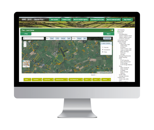
Find out more

Earth Observation & Machine Learning

Transforming vast satellite data into near‑real-time, nationwide land insights with 90–98% accuracy, enabling scalable and objective monitoring of land use and crops.

UK Land Management System Requirements

The system is designed to meet the specific needs of UK land monitoring and Environmental Land Management (ELM) schemes:

  • Compliance Verification – Ensure land-use practices meet UK environmental and subsidy regulations.
  • Universal Monitoring – Cover all agricultural and managed lands across England, Scotland, Wales, and Northern Ireland.
  • Timely Reporting – Deliver near-real-time insights to support policy decisions and subsidy payments.
  • Sub-Parcel Level Monitoring – Detect changes and manage fields at detailed parcel-level granularity.
  • Bespoke Algorithms – Tailored models for land-use classification, crop monitoring, and change detection.
  • Integration with LPIS – Seamless connection with the UK Land Parcel Identification System for accurate record-keeping.
  • Spatial Checks – Automated verification of field boundaries and land use.
  • Crop Classification – Identify crop types to support scheme compliance and agricultural planning.
  • Marker Identification – Detect key environmental or compliance markers across fields.
  • Interface & Expert Tools – Centralised dashboards and an Expert Viewer App for traceability, quality control, and efficient field assessments.

Nutrient Management Planning System

An online tool to support the creation of 50,000 farm plans across Ireland. 

The Nutrient Management Planning system is an enterprise scale solution that creates detailed farm plans suited to the farmer and to regulatory compliance.

Our sister company based in Ireland, Compass Informatics,  developed an online Nutrient Management Planning platform for Teagasc that enables the creation of up to 50,000 farm plans annually across Ireland. Using web-based tools, digital mapping, and a planning wizard, the system helps farmers target limited nutrients more effectively across their land. Designed with a strong emphasis on ease of use, the platform supports up to 500 farm advisors who use it to produce nutrient management plans for farmers.

The system is also capable of enhancement over time to reflect changing needs and regulations and will be capable of handling the expected increased demand for plans over the coming years.

Find Out More

Supporting Defra Group Bodies & UK Paying Agencies with Advanced Geospatial Intelligence

Tracsis GeoIntelligence partners with the Rural Payments Agency (RPA) to deliver advanced geospatial analytics and remote monitoring services. Our solutions help UK Paying Agencies:

  • Monitor land and environmental compliance remotely.
  • Verify scheme eligibility and subsidy compliance efficiently.
  • Detect land use changes and environmental risks.
  • Access scalable, near‑real-time insights across agricultural programmes.

The contract also allows other Defra Group Bodies and UK Paying Agencies to use the service under the same agreement, extending its impact across the UK’s environmental and agricultural landscape.

Request a callback from one of our team members to discuss how we can support your organisation. We treat all enquiries with care and will be in touch personally to provide tailored guidance.

Request callback
Speak to a team member

Start the Conversation

Get the answers you need. Start your geospatial journey with Tracsis Geo Intelligence and get in touch with our specialists to learn more.

Request A Callback - Consultancy

Please complete the form below to speak with one of our team members about how Tracsis GeoIntelligence can support your organisation. We treat all enquiries with care and will respond personally to discuss your requirements and provide tailored guidance.

Name(Required)
Email(Required)
Preferred Contact Time
:
Please specify any points of urgency or let us know if you would like to request a demo. The more information you provide, the better we can tailor our callback to your needs.
Tracsis Geo Intelligence

Our Clients