Skip to content
Reveals Spatial Inequality Across Transport Network

A single map shows step-free coverage, walkable catchment areas, and interchange connectivity across every station, making it immediately clear where urban and rural provision diverges.

Links Access Gaps to Essential Services Impact

By layering in hospitals, GP surgeries, care homes, and employment centres, the platform reveals not just where gaps exist, but where they hurt most. A station without step-free access matters very differently depending on what’s nearby.

Targets Investment to Highest-need Areas

Operators can identify which station upgrades unlock the largest underserved populations, and build investment cases that are defensible to boards, funders, and the public, shifting from gut instinct to clear spatial evidence.

Measure Change and Progress Over Time
  1. As improvements are delivered, the platform monitors changes in accessibility coverage over time, supporting regulatory reporting, ESG commitments, and stakeholder transparency.

Unifying fragmented rail accessibility data into actionable insight

Regional rail operators are under growing pressure to improve step-free access, demonstrate progress to regulators, and make limited budgets stretch further. The data usually exists, station audits, GIS layers, passenger feedback – but it’s fragmented. Without a clear, structured view, it becomes difficult to identify where the real accessibility gaps are, how significant they are, or what closing them would actually unlock for communities.

That’s the problem our accessibility mapping platforms are built to solve.

Identifying Critical Gaps in Public Service Connectivity

By overlaying key destinations such as hospitals, GP surgeries, and care facilities, transport organisations can identify where rail accessibility falls short of public need.

For example:

  • A major hospital may sit within a poorly connected rail catchment
  • Rural populations may face limited step free access to essential services
  • High-demand routes may lack inclusive infrastructure

This enables a shift from infrastructure-led planning to needs-based accessibility planning.

Our Solutions, Built on Real Experience

Trusted across transport, mobility, and planning programmes, our accessibility mapping capability helps operators understand how their networks perform in real-world terms, who can access services, where gaps exist, and what improvements can have the greatest impact.

We have delivered accessibility story maps, network analysis, and demand modelling for organisations including Healthy Ireland Local Government and Citi Logik, alongside a national-scale accessibility mapping solution for the National Transport Authority integrating infrastructure, walkability, demographics, and key services such as hospitals and schools. Our accessibility mapping and Analytics Tools support transport organisations such as rail operators to move from fragmented data to a single, evidence-led view of accessibility to support investment and planning decisions.

Using Earth Observation and Land Management Systems to Create Climate Resilient Railway Corridors

Connecting environmental intelligence to the operational decisions you’re already making.

Measurable Outcomes for Rail Accessibility

  1. More people can use the network – Real improvements in who can access rail, not just on paper.
  2. Investment goes where it matters – Evidence leads, removing guesswork from capital decisions.
  3. Stronger regulatory alignment – Data-backed plans that demonstrate genuine, measurable progress.
  4. A better sustainability story – Inclusive, accessible rail drives modal shift and climate benefit.

Tracsis Geo Intelligence, Your GIS Partner for Transport Advancement

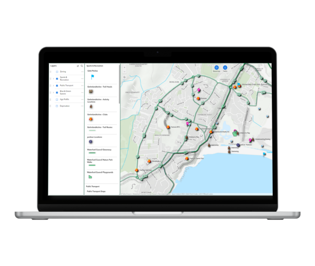
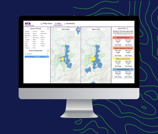
Tracsis Geo Intelligence offers a suite of GIS & Data Analytics Services to help transportation authorities harness the full potential of AI and EO.

Our expertise spans GIS data collection, management, analysis, and visualisation, enabling us to provide tailored solutions that address specific transportation challenges.

GIS Data Analytics Services

  • Develop and implement AI algorithms to analyse transportation data and generate actionable insights.
  • Create comprehensive dashboards and visualisations to present insights effectively.
  • Provide predictive analytics to forecast traffic patterns, identify potential disruptions, and optimise resource allocation.

GIS Advisory Services

  • Conduct GIS consultancy to assess transportation needs, identify data requirements, and develop implementation strategies.
  • Provide change management support to ensure smooth integration of GIS technologies into existing transportation systems.
  • Advice on regulatory compliance and data security best practices for GIS-based transport solutions.

By combining AI, EO, and GIS capabilities, Tracsis Geo Intelligence empowers transportation authorities to reimagine their systems, optimising efficiency, enhancing safety, and promoting sustainable mobility solutions for a brighter future of transportation.

How can we help?

Start the Conversation

Get the answers you need. Start your geospatial journey with Tracsis Geo Intelligence and get in touch with our specialists to learn more.

This field is for validation purposes and should be left unchanged.
Name(Required)
Email(Required)
Please let us know what's on your mind. Have a question for us? Ask away.